Map of Petare: Boundaries, Old Town, Neighborhoods and How to Get There
Interactive map of Petare (Caracas): parish boundaries, historic center, neighborhoods, metro and places of interest, with directions to each.
In this article 6
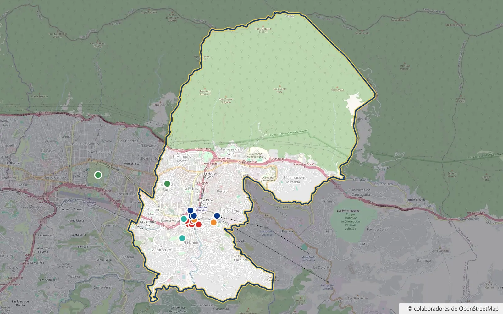
Where does Petare begin and end? How do you get to Plaza Sucre or the Bárbaro Rivas Museum? This interactive map shows the parish boundaries, the places of the historic center and the key points for getting around: metro, Cabletrén, markets, hospitals and parks.
Tap any point to see what it is, read its article or get directions. The map data comes from OpenStreetMap, the free map maintained by volunteers around the world.
Heritage and culture
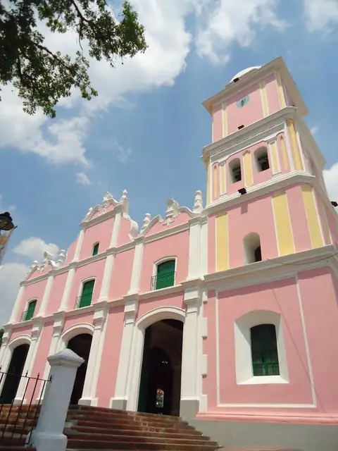
- · Read the articleMain church of the colonial old town, facing Plaza Sucre.
- · Read the articleThe former Main Square, heart of the historic center.
- · Read the article18th-century mansion devoted to folk art.
- · Read the articleCorner of Guánchez and Pacheco streets. (approximate location (street corner))
- · Read the articleCorner of Miranda and Pacheco streets. (approximate location (street corner))
- · Read the articleHome of painter Tito Salas, now a cultural center.
- · Read the articleFolk culture workshops in the historic center.
Markets
- · Read the articleThe barrio's historic market.
- · Read the articleNeighborhood market east of the old town.
- · Read the articleMajor transport hub and street market.
Transport
- · Read the articleA short walk from the historic center.
- · Read the articleConnection with the MetroCable.
- · Read the articleCable train up to the barrios of Petare Norte.
- · Read the articleBuses and routes to other areas.
Health
- · Read the articleFounded with Ana Francisca Pérez de León's donation.
- · Read the articleMain hospital in the area, in El Llanito.
Parks
- · Read the articleLagoon and paths in El Marqués Sur.
- · Read the articleOutside the parish, about 4 km from the old town.
Where Petare is
Petare is a parish of the Sucre municipality in Miranda state, and its capital. It lies in eastern Caracas and is part of the Metropolitan District. The Sucre municipality has five parishes: Petare, Leoncio Martínez, La Dolorita, Caucagüita and Fila de Mariche.
According to the official boundaries recorded in OpenStreetMap, Petare parish borders:
- To the west, Leoncio Martínez parish, home to Parque del Este.
- To the east and southeast, the parishes of Caucagüita and La Dolorita.
- To the south, El Cafetal parish (Baruta municipality) and El Hatillo municipality.
- To the north, the ridge of El Ávila, which separates it from La Guaira state (Caraballeda and Naiguatá parishes).
In everyday speech, "Petare" often covers more than the parish: many people in Caracas also use the name for barrios in La Dolorita, Caucagüita or Fila de Mariche.
Northern Petare is mountain
One surprise on the map: much of the parish is not streets but mountain. Its boundary climbs into Waraira Repano (El Ávila) National Park up to the area of Naiguatá peak (2,765 m). Homes are concentrated in the south, between the highway and the Guaire river; to the north are the green slopes visible from all over eastern Caracas. Read more about them in green spaces in Petare.
Walking route through the old town
The colonial center is small: from the metro station to Hacienda El Toboso it's less than 2 km. Here is a route in order, with everything marked on the map:
- Petare metro station (Line 1). The square is about 200 meters away.
- Plaza Sucre, the former Main Square, with the Church of Dulce Nombre de Jesús and, on the same Calle Madelene, Fundación Bigott.
- Bárbaro Rivas Museum of Folk Art, about 150 meters south.
- Chapel of Santa María Magdalena (El Calvario), on the corner of Guánchez and Pacheco streets.
- Casa de los León, now a public library, on the corner of Miranda and Pacheco streets.
- Petare Municipal Market, next to the Redoma.
- Hacienda El Toboso, painter Tito Salas's home, now the Tito Salas Cultural House.
As in any big city, it's best to explore during the day and, on your first visit, with someone who knows the area.
Neighborhoods of the parish
Petare combines middle-class neighborhoods, working-class barrios and the colonial center. These are some of the sectors OpenStreetMap places inside the parish:
- Center: Casco de Petare, Lebrún, Buena Vista and Campo Rico.
- North: Petare Norte, the barrios 5 de Julio, 24 de Julio, 19 de Abril and San José, La Urbina, El Marqués and Terrazas del Ávila.
- East: Palo Verde, La Industria, Lomas del Ávila and Urbanización Miranda.
- South and west: El Llanito, Las Brisas, Macaracuay, La California, El Tanque and Carpintero.
For more on the parish, see Petare key facts.
Getting to and around Petare
- Caracas Metro, Line 1: Petare station (next to the old town and the Redoma) and Palo Verde, the end of the line.
- MetroCable: runs from Palo Verde towards La Dolorita and Mariche.
- Cabletrén: from Petare II station up to the barrios of Petare Norte (19 de Abril and 5 de Julio stations).
- Buses: the Petare bus terminal and the Redoma gather many of the routes linking Petare with the rest of Caracas.
- By car: the Gran Cacique Guaicaipuro Highway (formerly Francisco Fajardo) runs through the north of the parish, with an exit at the La Urbina interchange. Avenida Francisco de Miranda reaches the historic center.
More details in our guide to transport in Petare.
About this map
The parish outline, the streets and the location of each place come from OpenStreetMap (© OpenStreetMap contributors, ODbL license). The chapel and the Casa de los León are marked at the street corner given in their address, so their position is approximate.
Is a place missing or wrongly placed? Write to us and we'll add it.