Petare, Venezuela: Key Facts
Key facts about Petare: location, population, area and main features of this emblematic barrio of Caracas.
In this article 13
- Meaning of the name Petare
- Area of Petare
- Altitude of Petare
- Total population of Petare
- Population density of Petare
- What people from Petare are called
- Time zone of Petare
- Postal code of Petare
- Phone area code of Petare
- State of Petare
- Sectors and districts of Petare
- Neighboring areas of Petare
- Official website
Petare is one of the most iconic and populated barrios in Venezuela, known for its vast size and its rich cultural history. Located in the Sucre municipality, in eastern Caracas, Petare is an area that combines tradition with modern urban challenges.
In this article we give you a detailed overview of Petare, focusing on key aspects such as its area, population, density and other facts that shape its identity.
Meaning of the name Petare
Etymologically, the name "Petare" comes from the Carib words "pet" (face) and "are" (river), spoken by the Mariches indigenous people, meaning "facing the river". The name reflects the geography of the area, surrounded by mountains and crossed by several rivers and streams.
Area of Petare
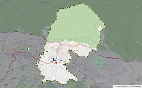
Petare parish covers about 40 km², according to the most widely cited figure. Measuring the full parish outline in OpenStreetMap gives about 55 km²: its northern boundary climbs the southern slope of Waraira Repano (El Ávila) National Park up to the area of Naiguatá peak, so much of the parish is mountain rather than city. You can see it on the map of Petare.
Altitude of Petare
Petare's old town sits at about 900 meters above sea level. This altitude, combined with its location in the Coastal Range, gives the area a relatively mild climate compared to other parts of Caracas.
Total population of Petare
According to the last national census by the National Statistics Institute (INE), in 2011, Petare parish had 372,470 inhabitants. It is the latest official count.
The INE's own projections, based on that census, put it at 448,861 inhabitants in 2020, and the whole Sucre municipality at 718,203, as published by the Sucre municipal government. But those projections do not reflect the large emigration of the last decade: the National Survey of Living Conditions (ENCOVI) by the Andrés Bello Catholic University records negative population growth in Venezuela in recent years. So the real figure is uncertain: emigration may have reduced it, and many barrio areas are hard to count.
Population density of Petare
Using the 2011 census, the density would be about 9,300 inhabitants per km² over 40 km², or about 6,700 over the full 55 km² outline including the mountain. In the barrio areas, where most people live, it is much higher. This density reflects the urban and social challenges the barrio faces, such as overcrowding and pressure on public services.
What people from Petare are called
People from Petare are known as petareños and petareñas. The name is a symbol of identity and pride for residents who, despite the difficulties, keep a strong sense of community.
Time zone of Petare
Like the rest of Venezuela, Petare follows Venezuela Time (VET), which is UTC-4. The time zone stays the same all year round, as Venezuela does not observe daylight saving time.
Postal code of Petare
Petare's postal code is 1073. It is essential for addressing mail and delivering services in the area.
Phone area code of Petare
The phone code for Petare is +58 212, the same used across the Caracas metropolitan area and other parts of Miranda state. It makes communication easy both within the country and internationally.
State of Petare
Petare is a parish in Miranda State, Venezuela. Located in the Sucre Municipality, it is known for its size and population, and is one of the most significant areas of the Caracas metropolitan area.
Sectors and districts of Petare
Petare is made up of a large number of sectors and barrios, each with its own identity and character. Some of the best-known sectors are:
- José Félix Ribas
- La Bombilla
- Palo Verde
- Mesuca
- Las Minas
- 5 de Julio
- 24 de Julio
- Barrio Unión
- San Blas
- Carpintero
- San Isidro
- Fechas Patrias
- La Alcabala
- El Tanque
- Cocolandia
- Pumarrosa
- Barrio Bolívar
- Guaicoco
- El Campito
Together, these sectors form a diverse and dynamic urban mosaic where community life and popular culture play a central role.
The Sucre municipality is divided into five parishes: Petare, Leoncio Martínez, La Dolorita, Caucagüita and Fila de Mariche. Although neighboring areas are often colloquially called "Petare" or "Greater Petare", administratively La Dolorita, Caucagüita, Fila de Mariche and Leoncio Martínez are separate parishes.
Neighboring areas of Petare
According to the official boundaries recorded in OpenStreetMap, Petare parish borders:
- To the north: the ridge of El Ávila (Waraira Repano National Park), which separates it from La Guaira state.
- To the south: El Cafetal parish (Baruta municipality) and El Hatillo municipality.
- To the east and southeast: the parishes of Caucagüita and La Dolorita.
- To the west: Leoncio Martínez parish.
This location connects Petare with major routes and access points in the city, although it also brings challenges in terms of mobility and urbanization.
Official website
Petare falls under the jurisdiction of the Sucre Municipality of Miranda state. For more information about public services, local initiatives and news, residents can visit the municipality's official website: alcaldiamunicipiosucre.gov.ve